So this will be the first post written by me (Dave). For those of you that know me well, I do have a bit of an inner geek, so this post is going to be of a technical nature. There are lots of opportunities to geek up a boat, and I thought I would go through some of the gear we have on Desolina that we have found particularly useful, and others that have turned out to be less useful than we first thought.
Electricity
We don’t use a huge amount of power on board, but it does run quite a few key systems so it’s important to make sure we always have enough of the stuff. When we bought the boat, the previous owner had recently installed 4 new batteries to supply power to all the gadgets (440Ah in total, with a separate battery just for starting the engine). We have a big inverter to supply the boat with AC power, although we very rarely use it. The majority of power use is DC, and is mostly made up of:
- Running the fridge 24/7 to keep the beers cold
- Charging our laptop, phones, iPad and Kindles – including watching a film most nights on the TV now the days are getting shorter.
- Lights, fans and water pump
- Navigation and VHF
To keep on top of our energy uses, we use a bunch of solar panels (210W) and the engine alternator (80A) to charge the batteries. The solar panels have been great, and overall probably supply us with most of our power. Certainly in the middle of summer we could stay on anchor for days with the solar panels keeping pace with our power use. We love not having to run the engine at anchor but now that summer is fading and we have less sunlight each day, we find after a couple of days we need to go for a motor to top up the batteries. For out-of-summer cruising I can really see the benefit of a wind turbine… Perhaps my next Christmas present Ruth?
 |
| We have four solar panels mounted on our bimini. Two solid ones at the rear, and two flexible ones in front which we bought to help keep the weight down. These are all wired into a MPP controller (fancy pants charging system) |
Navigation
The boat came with a couple of handheld GPS’s, an older chart plotter with radar, and a bunch of instruments that worked sporadically. Before we left Wellington, we made quite a few upgrades to the instruments. We put in a Raymarine i70 display with all new wind/speed/depth/temperature transducers (sensors). This has been really useful, and when at anchor we always set shallow and deep depth alarms to help warn us if we’ve dragged the anchor, as well as a wind alarm to warn us if the wind gets up in the night.
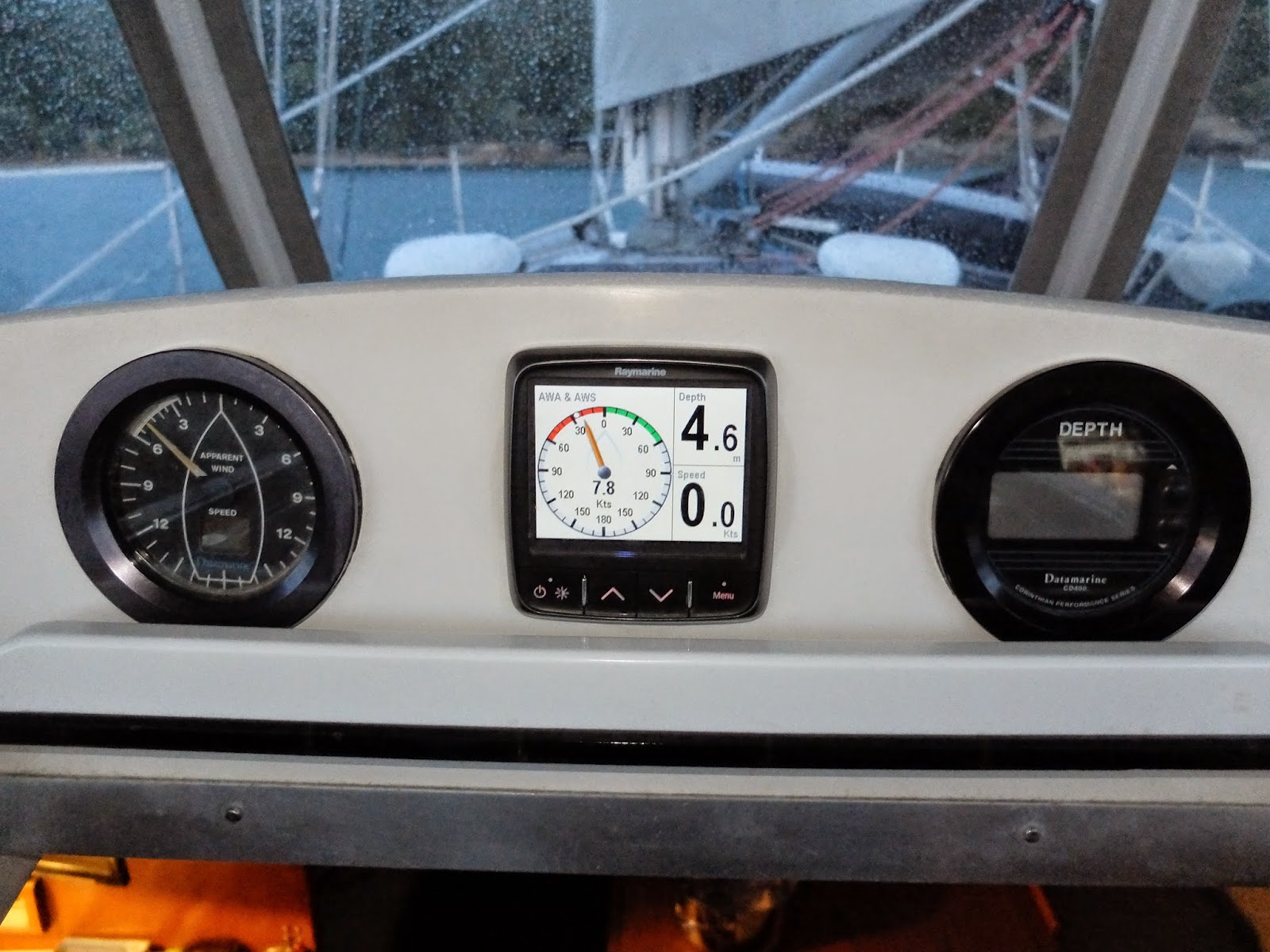 |
| Our new i70 display next to the old ones. The i70 can be programmed to show any data that is available to it on the network. The screen shown is dispaying the apparent wind speed and angle, depth and speed. |
The old chart plotter that we have works fine, but we don’t have any of the NZ charts on it as they’re quite expensive. So for navigating on Desolina we have the following:
- A little netbook computer (eee 900) with Navigatrix and OpenCPN
- Our MacBook with OpenCPN
- iPhone and iPad with SeaIQ
Navigatrix and OpenCPN are both great free packages, and the SEAiq app is only $40 (and the only app that allows you too use your own charts instead of buying them for a premium). With all of these we use the free marine charts from LINZ. We used to always have the netbook running when we were sailing, and connected up to our TV screen, which we could quickly turn on whenever we wanted to check our position. The netbook is also wired into our instruments and AIS (more on that later), as well as our wifi onboard so we have all the information we could ever want. Recently however, we’ve found that we’re using the netbook less and less and predominantly using just an iPhone with the SeaIQ app for checking our position when out sailing. For journey planning we normally use OpenCPN on the MacBook. We’ve found the iPhone is so much easier to use as we just keep it in a pocket and can have a quick check of our position really quickly. Even when navigating through tight passages we’ve found even with the phone’s small screen it’s fine.
 |
| OpenCPN running on our TV screen, powered by the netbook which is safely hidden away under the shelfs on the left. OpenCPN is also re-transitting all the data to the wifi which is picked up SEAiq on the iPad and iPhone. Major geek points. |
And of course we have all the paper charts (bear in mind that these are exactly the same as the digital copies we have) for where we’re sailing but come on, who uses those anymore!
Two things that I had never used before (or heard of for the latter) are radar and AIS. For the uninitiated, AIS or Automatic Identification System, is a system that uses VHF radio to transmit a ship's position (as well as speed, call-sign and dimensions) and is mandatory for all large vessels. We don’t have an AIS transmitter, but our VHF radio can receive signals from other boats. This means that from either the VHF screen, or the computer if we have it running, we can see the positions of all the big ships around us and can see if we’re going to get close to any of them. When going through tight passages with blind corners, at night, or in a busy harbour, AIS is awesome. The main VHF unit is down below at the chart table, but we have a remote unit for it that has a small screen which displays the AIS targets like on a radar screen and we keep this up in the cockpit so we can quickly check on nearby vessels.
 |
| This is a screenshot of OpenCPN whilst connected up to the boat instruments (showing wind and depth in the right) and the VHF radio showing the AIS targets. The day we took this we were heading towards Opua and the line of boats you can see passing in front of us was the ICA rally. |
Radar as well is something that I now would never venture too far without. It’s proved invaluable when sailing in poor weather or at night. Our radar screen is on the binnacle (where the steering wheel is...) so you can only see it when you’re stood behind the wheel. This has been great when manoeuvring at close quarters, for example leaving an anchorage before sunrise, or entering a marina at night, but is a bit of a pain when sailing along with the autopilot engaged, like during night passages. On nights we’re normally huddled under the dodger at the front of the cockpit and if we want to check the radar, we have to scramble around the wheel to the back of the cockpit. Moving the radar screen to under the dodger would have its advantages.
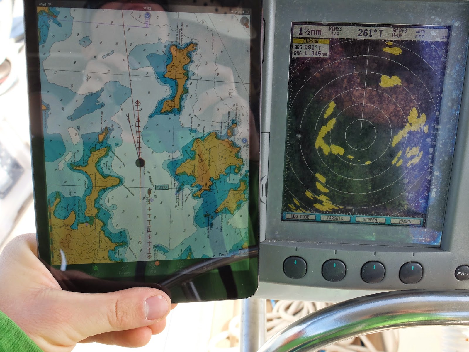 |
| Our iPad running SEAiq with GPS and AIS data from the boat wifi along side our radar. For those with a keen eye, you can see the AIS target we have just passed on the iPad, and its radar return (yellow blob at the 5 o'clock position on the second ring from centre) |
Autopilot
Our autopilot is called Geoffrey (aka Raymarine ST5000+). Why you would go sailing for more than a few hours with a shorthanded crew without a Geoffrey is beyond me. Who wants to sit at the helm steering in a straight line for hours on end! We have a small unit attached directly to the wheel, but it’s powerful enough to sail us in most conditions. Geoffrey does struggle a bit in big waves but apart from that has been an essential third crew member. He’s also clued up on what the wind’s doing, so can sail us on a constant wind angle which has been a lot more useful than I first thought. Coming up the East coast we were going into headwinds a lot more than we would have liked, but Geoffrey did a very nice job of keeping the boat on a perfect angle to the wind and thus keeping the sails at their optimum; a lot better than we could do after sailing nonstop for several days! He also sounds a little alarm if the wind direction changes too much to warn you that you’re now potentially sailing off course.
We’ve also got Alfred, a wind vane steering system (Cape Horn) that uses the power of the wind to keep the boat on course. Alfred is a bit of a dark horse and has so far been reluctant in his helming duties. The mystical art of wind vane steering has so far eluded us (although we haven’t tried all that much), and at-the-touch-of-a-button Geoffrey has always been the go to helmsman. I suspect Alfred would be much more useful out in the deep blue with more constant winds and where a little weaving in course wouldn’t end in ship wrecking.
I’ve quite enjoyed learning about marine electronics and it’s quite satisfiying when they all work together (for anyone contemplating doing DIY marine electronics, the key phrase is NMEA 0183, which is the “language” most of the devices use). But of course all electronics can suffer in the marine environment. Our Macbook being the latest fatality. I think the hard disk finally had enough of being constantly moved around! I’m currently writing this blog post up on our little netbook, which although is about twice the age of the Mac, has handled life afloat quite well!